
1971 Map of Parowan
USGS Topo · Published 1975About this map
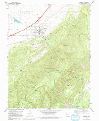
Parowan serves as the focal point of this 1970s survey, situated where the Parowan Valley meets the dramatic rising front of the Hurricane Cliffs. The town's layout includes a Race Track and City Airport, while an Aqueduct carries water from Parowan Creek to support the local agricultural base. To the southeast, the landscape transitions into the high terrain of the Dixie National Forest, a region defined by complex drainage systems and named landmarks like Valentine Peak and Noah Ark.
Find a feature on this map
61 named features on this map. Tap any name to fly to it.
Don’t see what you’re looking for? This feature index may not catch every label — zoom into the map to look around manually.
Map Details
Editions of this 1971 Parowan Map
2 editions found
Other maps of this area

1886 · Kanab
USGS Topo · 1:250,000

1953 · Cedar City
USGS Topo · 1:250,000

1958 · Cedar City
USGS Topo · 1:250,000

1958 · Cedar Breaks
USGS Topo · 1:62,500

1958 · Panguitch Lake
USGS Topo · 1:62,500

1962 · Cedar City
USGS Topo · 1:250,000

1971 · Paragonah
USGS Topo · 1:24,000
1971 · Summit
USGS Topo · 1:24,000
1971 · Cottonwood Mtn
USGS Topo · 1:24,000
1971 · Parowan Gap
USGS Topo · 1:24,000