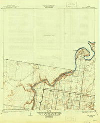
1933 Map of Paso Real
USGS Topo · Published 1945About this map
Arroyo Colorado snakes through the landscape of the Rio Grande Valley in this topographic study, defining the boundary between Willacy and Cameron counties. The settlement at Paso Real marks a vital crossing point on the waterway where a Ferry once operated, serving as a gateway for travelers moving through this citrus and agricultural region. Further south, the map reveals the organized grid of the Fernando settlement, situated along the Missouri Pacific railroad line.
Find a feature on this map
12 named features on this map. Tap any name to fly to it.
Don’t see what you’re looking for? This feature index may not catch every label — zoom into the map to look around manually.
Map Details
Editions of this 1933 Paso Real Map
2 editions found
Other maps of this area

1929 · Rio Hondo
USGS Topo · 1:24,000

1929 · Harlingen
USGS Topo · 1:24,000

1930 · La Leona
USGS Topo · 1:24,000

1930 · Laguna Atascosa
USGS Topo · 1:24,000

1932 · Combes
USGS Topo · 1:31,680

1932 · Rio Hondo
USGS Topo · 1:31,680

1932 · Harlingen
USGS Topo · 1:31,680

1933 · Paso Real
USGS Topo · 1:31,680

1936 · La Leona
USGS Topo · 1:31,680
1936 · Laguna Atascosa
USGS Topo · 1:31,680