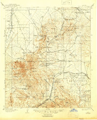
1905 Map of Patagonia
USGS Topo · Published 1946About this map
Santa Rita Mountains and the Empire Mountains dominate this early 20th-century landscape, which was surveyed when mining and cattle ranching drove the regional economy. The map identifies numerous active operations and claims, including the Total Wreck Mine, Cuprite Mine, and the Helena Mine near Helvetia. A network of family-owned ranching estates, such as Empire Ranch and Lopez's Ranch, are scattered throughout the valleys and foothills, illustrating the settlement patterns of the Arizona Territory just years before statehood. Historical military and transit landmarks appear, including the site of Old Ft Crittenden and the Southern Pacific RR corridor through Sonoita. The inclusion of the Santa Rita Experimental Range and facilities like the Montosa Mill highlight the area's dual role as a center for both mineral extraction and emerging land management research.
Find a feature on this map
105 named features on this map. Tap any name to fly to it.
Don’t see what you’re looking for? This feature index may not catch every label — zoom into the map to look around manually.
Map Details
Editions of this 1905 Patagonia Map
4 editions found
Other maps of this area

1904 · Patagonia
USGS Topo · 1:125,000

1904 · Tucson
USGS Topo · 1:125,000

1905 · Patagonia
USGS Topo · 1:125,000

1905 · Tucson
USGS Topo · 1:125,000

1905 · Nogales
USGS Topo · 1:125,000

1914 · Hereford
USGS Topo · 1:125,000

1915 · Benson
USGS Topo · 1:125,000

1920 · Arivaca
USGS Topo · 1:125,000

1921 · Old Glory
USGS Topo · 1:125,000

1922 · Agus Caliente
USGS Topo · 1:62,500