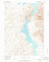
1953 Map of Pathfinder Reservoir SW
USGS Topo · Published 1971About this map
Pathfinder Reservoir dominates this high-altitude landscape in central Wyoming, serving as a focal point for water management and wildlife conservation in the early 1950s. The map illustrates the rugged interface between the water's edge and the surrounding peaks, most notably the Pedro Mountains rising to the east. This survey, conducted as part of the Department of the Interior program for the development of the Missouri River Basin, documents the Pathfinder National Wildlife Refuge established along the reservoir's western bays. A network of ephemeral drainages, including Sand Creek, Bear Creek, and Deweese Creek, carve through the arid terrain, while the isolated Park Ranch stands as a solitary marker of human habitation. The prevalence of a Jeep Trail winding through the hills reflects the remote character of the region during this era of post-war resource mapping.
Find a feature on this map
14 named features on this map. Tap any name to fly to it.
Don’t see what you’re looking for? This feature index may not catch every label — zoom into the map to look around manually.
Map Details
Editions of this 1953 Pathfinder Reservoir SW Map
4 editions found
Other maps of this area

1951 · Pathfinder Reservoir NW
USGS Topo · 1:24,000

1951 · Pathfinder Dam
USGS Topo · 1:24,000

1951 · Fort Ridge
USGS Topo · 1:24,000

1953 · Leo
USGS Topo · 1:24,000

1953 · Bradley Peak
USGS Topo · 1:24,000

1953 · Seminoe Dam NE
USGS Topo · 1:24,000

1953 · Seminoe Dam
USGS Topo · 1:24,000

1953 · Pathfinder Reservoir SW
USGS Topo · 1:24,000

1953 · Buzzard Ranch
USGS Topo · 1:24,000

1955 · Casper
USGS Topo · 1:250,000