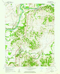
1959 Map of Patoka
USGS Topo · Published 1962About this map
The White River and Patoka River dominate this Southwestern Indiana landscape, where the confluence area is protected by an extensive drainage network. The Brevoort Levee and series of watercourses like Brevoort Ditch and Thompson Ditch illustrate the mid-century engineering required to manage the flood-prone bottomlands between Hazleton and Patoka. Settlement is concentrated along the Chicago and Eastern Illinois railroad corridor, which serves as a vital north-south artery for the region.
Find a feature on this map
43 named features on this map. Tap any name to fly to it.
Don’t see what you’re looking for? This feature index may not catch every label — zoom into the map to look around manually.
Map Details
Editions of this 1959 Patoka Map
4 editions found
Other maps of this area

1901 · Princeton
USGS Topo · 1:62,500

1902 · Ditney
USGS Topo · 1:125,000

1903 · Petersburg
USGS Topo · 1:62,500

1903 · Princeton
USGS Topo · 1:62,500

1903 · Patoka
USGS Topo · 1:125,000

1915 · Vincennes
USGS Topo · 1:62,500

1944 · Iona
USGS Topo · 1:24,000

1944 · Vincennes
USGS Topo · 1:62,500

1956 · Vincennes
USGS Topo · 1:250,000

1957 · Vincennes
USGS Topo · 1:250,000