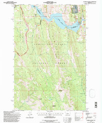
1995 Map of Patricks Basin
USGS Topo · Published 1997About this map
Gibson Reservoir dominates the northern landscape of this Rocky Mountain front survey, where the waters of the Sun River are impounded against the sheer rising face of the Sawtooth Range. The area is characterized by dramatic elevation shifts, from the low flats of Palmer Flats to the high summits of Allan Mountain and Elephant Head. A complex network of drainages including Lange Creek and Benchmark Creek carve through the Patricks Basin, illustrating the primitive character of the Lewis and Clark National Forest and the adjacent Bob Marshall Wilderness.
Find a feature on this map
39 named features on this map. Tap any name to fly to it.
Don’t see what you’re looking for? This feature index may not catch every label — zoom into the map to look around manually.
Map Details
Editions of this 1995 Patricks Basin Map
This is the sole edition of this map. No revisions or reprints were ever made.
Other maps of this area

1903 · Saypo
USGS Topo · 1:125,000

1903 · Coopers Lake
USGS Topo · 1:125,000

1955 · Choteau
USGS Topo · 1:250,000

1957 · Choteau
USGS Topo · 1:250,000

1958 · Choteau
USGS Topo · 1:250,000

1958 · Sawtooth Ridge
USGS Topo · 1:24,000

1958 · Glenn Creek
USGS Topo · 1:24,000

1958 · Pretty Prairie
USGS Topo · 1:24,000

1958 · Patricks Basin
USGS Topo · 1:24,000

1958 · Castle Reef
USGS Topo · 1:24,000