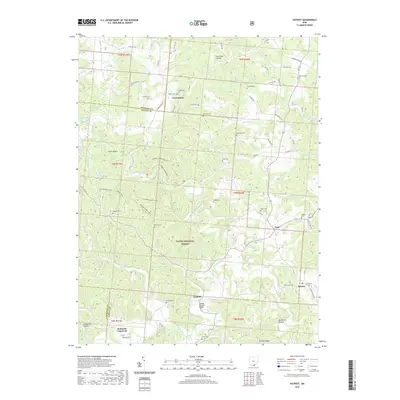
2019 Map of Patriot
USGS Topo · Published 2019About this map
The Wayne National Forest dominates the hilly terrain of Gallia and Jackson Counties, where numerous small settlements like Patriot and Centerpoint are linked by a complex network of township and county roads. The landscape is deeply incised by the Symmes Creek system, creating a series of hollows such as Hunt Hollow and Holcomb Hollow. This region is a focal point for genealogical research, evidenced by the high density of family-named burial grounds including Tyn Rhos Cem, Wiseman Cem, and Boggs Cem. Along the lower reaches of Symmes Creek, the Cadmus Covered Bridge stands near the community of Cadmus, highlighting the area's preserved rural infrastructure. The map also traces various recreational routes through the woods, including the Symmes Creek Trail N and the Symmes Creek Trail S, reflecting the area's transition toward conservation and forest management.
Find a feature on this map
83 named features on this map. Tap any name to fly to it.
Don’t see what you’re looking for? This feature index may not catch every label — zoom into the map to look around manually.
Map Details
Editions of this 2019 Patriot Map
This is the sole edition of this map. No revisions or reprints were ever made.
Other maps of this area

1898 · Ironton
USGS Topo · 1:62,500

1900 · Ironton
USGS Topo · 1:62,500

1906 · Bidwell
USGS Topo · 1:62,500

1906 · Athalia
USGS Topo · 1:62,500

1908 · Bidwell
USGS Topo · 1:62,500

1908 · Athalia
USGS Topo · 1:62,500

1912 · Oak Hill
USGS Topo · 1:62,500

1957 · Huntington
USGS Topo · 1:250,000

1960 · Huntington
USGS Topo · 1:250,000
1961 · Oak Hill
USGS Topo · 1:24,000