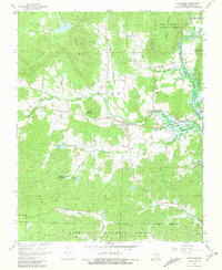
1968 Map of Patterson
USGS Topo · Published 1981About this map
Patterson sits at the heart of this late-1960s Ozark landscape, where the wooded ridges of Benton and Logan townships meet the waters of Lake Wappapello. The map documents a rural network of family-named landmarks and spiritual centers, from the Lebanon Ch in the west to Little Lake Creek Ch in the southeast. Numerous burial grounds such as English Cem, Sparks Cem, and the Fulton Spring Cem provide a deep record of local genealogy within the Missouri hills.
Find a feature on this map
42 named features on this map. Tap any name to fly to it.
Don’t see what you’re looking for? This feature index may not catch every label — zoom into the map to look around manually.
Map Details
Editions of this 1968 Patterson Map
3 editions found
Other maps of this area

1926 · Des Arc
USGS Topo · 1:62,500

1929 · Des Arc
USGS Topo · 1:62,500

1930 · Coldwater
USGS Topo · 1:62,500

1932 · Piedmont
USGS Topo · 1:62,500

1934 · Greenville
USGS Topo · 1:62,500

1935 · Piedmont
USGS Topo · 1:62,500

1939 · Greenville
USGS Topo · 1:62,500

1949 · Rolla
USGS Topo · 1:250,000

1949 · Coldwater
USGS Topo · 1:62,500

1953 · Rolla
USGS Topo · 1:250,000