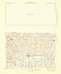
1925 Map of Pattonsburg
USGS Topo · Published 1925About this map
The Grand River and its major tributaries, including Sampson Creek and Big Creek, dominate this rural Missouri landscape. The hub of Pattonsburg serves as a central junction for both the Wabash and the Quincy Omaha and Kansas City railroads, highlighting the area's significance in early 20th-century transport. Northward, the village of Salem functions as a secondary rail stop near Cypress Creek.
Find a feature on this map
46 named features on this map. Tap any name to fly to it.
Don’t see what you’re looking for? This feature index may not catch every label — zoom into the map to look around manually.
Map Details
Editions of this 1925 Pattonsburg Map
3 editions found
Other maps of this area

1922 · Gallatin
USGS Topo · 1:62,500

1923 · Maysville
USGS Topo · 1:62,500

1924 · Winston
USGS Topo · 1:62,500

1925 · Pattonsburg
USGS Topo · 1:62,500

1925 · Gilman
USGS Topo · 1:62,500

1925 · Maysville
USGS Topo · 1:62,500

1925 · Darlington
USGS Topo · 1:62,500

1942 · Grant City
USGS Topo · 1:62,500

1943 · Grant City
USGS Topo · 1:62,500

1944 · Pattonsburg
USGS Topo · 1:62,500