
1965 Map of Pauls Valley
USGS Topo · Published 1966About this map
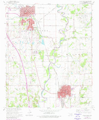
Pauls Valley serves as a major hub in this mid-1960s study of central Oklahoma, where the G C & S F RY and Atchison Topeka and Santa Fe railroads follow the winding course of the Washita River. The landscape reveals a heavy reliance on petroleum and mineral extraction, evidenced by the East Pauls Valley Oil Field, the Southeast Pauls Valley Oil Field, and a large Oil Refinery located just south of Wynnewood. Local infrastructure is well-defined, from the Pauls Valley Municipal Airport to the newly established path of Interstate 35. Social history is anchored by numerous institutions, including the State Sch and several neighborhood schools like Parkview Sch and Jefferson Sch. The map also meticulously records local resting places such as Mt Olive Cemetery and Oaklawn Cem, alongside community landmarks like Wacker Park and the local Drive-in Theater.
Find a feature on this map
43 named features on this map. Tap any name to fly to it.
Don’t see what you’re looking for? This feature index may not catch every label — zoom into the map to look around manually.
Map Details
Editions of this 1965 Pauls Valley Map
3 editions found
Other maps of this area

1898 · Pauls Valley
USGS Topo · 1:125,000

1902 · Pauls Valley
USGS Topo · 1:125,000

1957 · Ardmore
USGS Topo · 1:250,000

1963 · Ardmore
USGS Topo · 1:250,000

1964 · Byars
USGS Topo · 1:24,000

1965 · Pauls Valley NE
USGS Topo · 1:24,000

1965 · Byars SW
USGS Topo · 1:24,000

1965 · Davis
USGS Topo · 1:24,000

1965 · Joy
USGS Topo · 1:24,000

1965 · Paoli
USGS Topo · 1:24,000