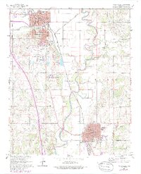
1965 Map of Pauls Valley
USGS Topo · Published 1986About this map
The Washita River snakes through the center of this 1960s Oklahoma landscape, defining the corridor between the bustling county seat of Pauls Valley and the industrial hub of Wynnewood to the south. This era shows a community rooted in education and industry, home to the sprawling Pauls Valley State Sch complex and its adjacent State Sch Cem. The presence of the Southeast Pauls Valley Oil Field and a significant Oil Refinery near Wynnewood reflects the region's mid-century petroleum economy. Transportation is anchored by the Gulf Colorado and Santa Fe railroad, which meets the Atchison Topeka and Santa Fe at Gulf Junction. From the downtown Courthouse to neighborhood schools like Jefferson Sch and Jackson Sch, the map captures a detailed inventory of civic life before later highway expansions altered the local character.
Find a feature on this map
49 named features on this map. Tap any name to fly to it.
Don’t see what you’re looking for? This feature index may not catch every label — zoom into the map to look around manually.
Map Details
Editions of this 1965 Pauls Valley Map
3 editions found
Other maps of this area

1898 · Pauls Valley
USGS Topo · 1:125,000

1902 · Pauls Valley
USGS Topo · 1:125,000

1957 · Ardmore
USGS Topo · 1:250,000

1963 · Ardmore
USGS Topo · 1:250,000

1964 · Byars
USGS Topo · 1:24,000

1965 · Pauls Valley NE
USGS Topo · 1:24,000

1965 · Byars SW
USGS Topo · 1:24,000

1965 · Pauls Valley
USGS Topo · 1:24,000

1965 · Davis
USGS Topo · 1:24,000

1965 · Joy
USGS Topo · 1:24,000