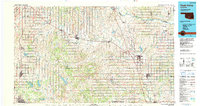
1986 Map of Pauls Valley
USGS Topo · Published 1990About this map
The Golden Trend Oil Field dominates the central landscape of this mid-1980s Oklahoma survey, illustrating the critical intersection of energy extraction and rural settlement. Centered on Pauls Valley, the map details a region defined by the winding course of the Washita River and its many tributaries, including Rush Creek and Wildhorse Creek. This era shows a mature infrastructure of rail and road, with the Atchison Topeka And Santa Fe railroad serving as a primary corridor through towns like Paoli and Wynnewood.
Find a feature on this map
81 named features on this map. Tap any name to fly to it.
Don’t see what you’re looking for? This feature index may not catch every label — zoom into the map to look around manually.
Map Details
Editions of this 1986 Pauls Valley Map
2 editions found
Other maps of this area

1893 · Norman
USGS Topo · 1:62,500

1896 · Seminole and Prague
USGS Topo · 1:125,000

1898 · Purcell
USGS Topo · 1:125,000

1898 · Pauls Valley
USGS Topo · 1:125,000

1901 · Stonewall
USGS Topo · 1:125,000

1901 · Addington
USGS Topo · 1:125,000

1901 · Tishomingo
USGS Topo · 1:125,000

1901 · Ardmore
USGS Topo · 1:125,000

1902 · Pauls Valley
USGS Topo · 1:125,000

1902 · Rush Springs
USGS Topo · 1:125,000