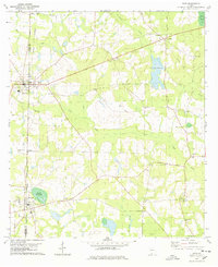
1978 Map of Pavo
USGS Topo · Published 1978About this map
The Georgia-Florida borderlands of Brooks and Thomas Counties are defined by a network of rural churches and agricultural homesteads centered around the town of Pavo. The landscape is etched with the historic Old Coffee Road, an early 19th-century pioneer trail that cuts diagonally through the southern half of the quadrangle. This thoroughfare connects local landmarks like Harmony Ch and the settlement of Barwick, reflecting the area's long-standing importance in regional transit. The terrain is marked by distinctive hydrological features including Lake Nichols and Pope Millpond, while numerous family and community burial grounds like Lebanon Cem and Oak Grove Cem offer significant touchstones for local genealogical research. In the late 1970s, the GEORGIA NORTHERN railroad line remained a vital artery, threading through Hollis and connecting these small agricultural communities to larger markets.
Find a feature on this map
30 named features on this map. Tap any name to fly to it.
Don’t see what you’re looking for? This feature index may not catch every label — zoom into the map to look around manually.
Map Details
Editions of this 1978 Pavo Map
2 editions found
Other maps of this area

1953 · Waycross
USGS Topo · 1:250,000

1954 · Valdosta
USGS Topo · 1:250,000

1957 · Thomasville
USGS Topo · 1:62,500

1958 · Valdosta
USGS Topo · 1:250,000

1958 · Waycross
USGS Topo · 1:250,000

1959 · Valdosta
USGS Topo · 1:250,000

1961 · Quitman
USGS Topo · 1:62,500

1974 · Berlin East
USGS Topo · 1:24,000
1974 · Quitman
USGS Topo · 1:24,000
1975 · Pebble Hill
USGS Topo · 1:24,000