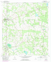
1978 Map of Pavo
USGS Topo · Published 1987About this map
The town of Pavo sits at the western edge of this South Georgia landscape, straddling the line between Thomas and Brooks counties in the late 1970s. The settlement pattern here is defined by small agricultural centers and a network of country churches and family burial grounds, reflecting the deep-rooted rural community structure. To the south, Barwick anchors the corner of the map near the Georgia Northern rail line, which cuts a diagonal path through the terrain. The presence of the Old Coffee Road provides a tangible link to Georgia's early 19th-century pioneer transport routes, still visible as a functional corridor amidst the modern topography. Water dominates the eastern half of the sheet, where Mule Creek and Little Creek meander through lowlands, feeding into managed water bodies like Lake Nichols and Pope Millpond. Genealogists will find a wealth of named sites including Lebanon Cem, Mt Zion Ch Cem, and Okapilco Cem.
Find a feature on this map
31 named features on this map. Tap any name to fly to it.
Don’t see what you’re looking for? This feature index may not catch every label — zoom into the map to look around manually.
Map Details
Editions of this 1978 Pavo Map
2 editions found
Other maps of this area

1953 · Waycross
USGS Topo · 1:250,000

1954 · Valdosta
USGS Topo · 1:250,000

1957 · Thomasville
USGS Topo · 1:62,500

1958 · Valdosta
USGS Topo · 1:250,000

1958 · Waycross
USGS Topo · 1:250,000

1959 · Valdosta
USGS Topo · 1:250,000

1961 · Quitman
USGS Topo · 1:62,500

1974 · Berlin East
USGS Topo · 1:24,000
1974 · Quitman
USGS Topo · 1:24,000
1975 · Pebble Hill
USGS Topo · 1:24,000