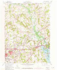
1960 Map of Pavonia
USGS Topo · Published 1973About this map
The Charles Mill Lake reservoir and the surrounding Muskingum Watershed Conservancy District dominate the eastern landscape of this Richland County region. The map captures a period of transition as the residential footprints of Mansfield, East Mansfield, and Lincoln Heights expand eastward. While industrial development is evident near the Penn Central and Erie-Lackawanna rail lines, the northern sections maintain a rural character defined by family-named cemeteries such as Imhoff Cem and Pittenger Cem. Local social geography is marked by landmarks like the County Home and the Drive-in Theater along the highway near Windsor. The winding course of the Black Fork and Mohican River provides a natural contrast to the grid of country roads and established settlements like Pavonia and Epworth.
Find a feature on this map
64 named features on this map. Tap any name to fly to it.
Don’t see what you’re looking for? This feature index may not catch every label — zoom into the map to look around manually.
Map Details
Editions of this 1960 Pavonia Map
3 editions found
Other maps of this area

1908 · Ashland
USGS Topo · 1:62,500

1912 · Perrysville
USGS Topo · 1:62,500

1915 · Crestline
USGS Topo · 1:62,500

1915 · Perrysville
USGS Topo · 1:62,500

1915 · Shauck
USGS Topo · 1:62,500

1943 · Shauck
USGS Topo · 1:62,500

1943 · Crestline
USGS Topo · 1:62,500

1944 · Perrysville
USGS Topo · 1:62,500

1950 · Marion
USGS Topo · 1:250,000

1960 · Pavonia
USGS Topo · 1:24,000