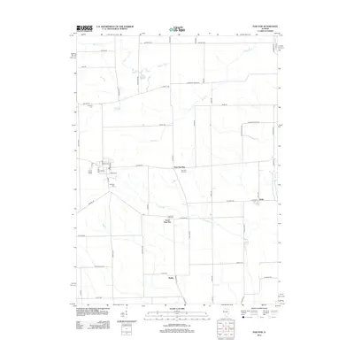
2012 Map of Paw Paw
USGS Topo · Published 2012About this map
Wyoming Cemetery and the various neighborhoods around South Paw Paw reveal the rural character of Wyoming Township in the early 21st century. This survey documents a landscape defined by an orderly grid of local roads, such as Chicago Road and Angling Road, which connect small clusters like East Paw Paw and Rollo. Water features including Stroyan Lake and Paw Paw Run cut across these agricultural plots, providing natural drainage for the surrounding fields. The map also records several local burial grounds essential for genealogical research, including Ellsworth Cemetery, East Paw Paw Cemetery, and South Paw Paw Cemetery. The presence of the namesake settlement and its eastern and southern extensions suggests a history of localized growth along these interior country routes.
Find a feature on this map
61 named features on this map. Tap any name to fly to it.
Don’t see what you’re looking for? This feature index may not catch every label — zoom into the map to look around manually.
Map Details
Editions of this 2012 Paw Paw Map
This is the sole edition of this map. No revisions or reprints were ever made.
Other maps of this area

1934 · De Kalb
USGS Topo · 1:62,500

1937 · De Kalb
USGS Topo · 1:62,500

1951 · Earlville
USGS Topo · 1:62,500

1952 · Rochelle
USGS Topo · 1:62,500

1952 · Mendota
USGS Topo · 1:62,500

1958 · Aurora
USGS Topo · 1:250,000

1961 · Aurora
USGS Topo · 1:250,000
1971 · Leland
USGS Topo · 1:24,000
1971 · Lee
USGS Topo · 1:24,000
1971 · Paw Paw
USGS Topo · 1:24,000