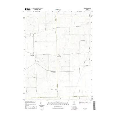
2015 Map of Paw Paw
USGS Topo · Published 2015About this map
Paw Paw and its satellites anchor this agricultural landscape at the tri-county junction of Lee, DeKalb, and LaSalle. The village structure reflects a history of small, interconnected rural centers, with East Paw Paw, South Paw Paw, and Rollo situated along the drainage of Paw Paw Run and Indian Cr. The distribution of local landmarks like Wyoming Cem and Ellsworth Cem provides a detailed view of the early township settlements that formed around these watercourses and local roads. In the northern reaches, Stroyan Lake and Willow Cr suggest the natural hydrology that influenced the placement of farms and cemeteries like Johnson Grove Cem. This survey illustrates the persistence of the classic grid-iron township system, where primary thoroughfares like Chicago Rd and Earlville Rd continue to connect the scattered communities across the prairie.
Find a feature on this map
59 named features on this map. Tap any name to fly to it.
Don’t see what you’re looking for? This feature index may not catch every label — zoom into the map to look around manually.
Map Details
Editions of this 2015 Paw Paw Map
This is the sole edition of this map. No revisions or reprints were ever made.
Other maps of this area

1934 · De Kalb
USGS Topo · 1:62,500

1937 · De Kalb
USGS Topo · 1:62,500

1951 · Earlville
USGS Topo · 1:62,500

1952 · Rochelle
USGS Topo · 1:62,500

1952 · Mendota
USGS Topo · 1:62,500

1958 · Aurora
USGS Topo · 1:250,000

1961 · Aurora
USGS Topo · 1:250,000
1971 · Leland
USGS Topo · 1:24,000
1971 · Lee
USGS Topo · 1:24,000
1971 · Paw Paw
USGS Topo · 1:24,000