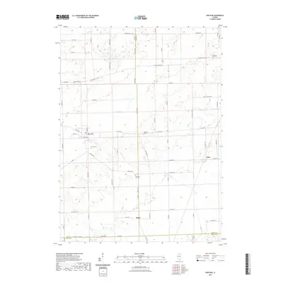
2021 Map of Paw Paw
USGS Topo · Published 2021About this map
Paw Paw anchors this rural landscape where the boundaries of Lee, DeKalb, and LaSalle counties converge. The drainage of Indian Cr and the Paw Paw Run define the agricultural layout of the region, punctuated by small clusters of settlement like Rollo and Radley. This modern survey reveals a persistent pattern of local history through its numerous burial grounds, including the Shabbona Grove Cem and Wyoming Cem. The road network follows a rigid grid typical of the Illinois prairie, yet is broken by the diagonal path of Chicago Rd, a historic corridor connecting these farming communities. North of the primary settlement, Stroyan Lake and Willow Cr offer a break in the geometric fields, providing a look at the natural water features that influenced early land claims and the eventual placement of homesteads in Wyoming Township.
Find a feature on this map
64 named features on this map. Tap any name to fly to it.
Don’t see what you’re looking for? This feature index may not catch every label — zoom into the map to look around manually.
Map Details
Editions of this 2021 Paw Paw Map
This is the sole edition of this map. No revisions or reprints were ever made.
Other maps of this area

1934 · De Kalb
USGS Topo · 1:62,500

1937 · De Kalb
USGS Topo · 1:62,500

1951 · Earlville
USGS Topo · 1:62,500

1952 · Rochelle
USGS Topo · 1:62,500

1952 · Mendota
USGS Topo · 1:62,500

1958 · Aurora
USGS Topo · 1:250,000

1961 · Aurora
USGS Topo · 1:250,000
1971 · Leland
USGS Topo · 1:24,000
1971 · Lee
USGS Topo · 1:24,000
1971 · Paw Paw
USGS Topo · 1:24,000