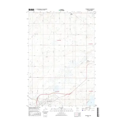
2016 Map of Paynesville
USGS Topo · Published 2016About this map
Paynesville anchor this Stearns County landscape, where the northern plains are defined by the winding course of the Sauk River and the N Fork Crow River. The regional layout reveals a high concentration of water-managed terrain, visible in the numerous small wetlands and basins that dot the townships of t123n r32w and t122n r32w. Small agricultural hubs like Roscoe and Saint Martin serve as the primary nodes for a grid of county roads, including Co Hwy 33 and Sauk Valley Rd. Local history is preserved in several rural burial grounds such as Salem Cem, Zion Cem, and Saint Louis Cem, which remain as distinct landmarks amidst the expansive farmsteads. The southern edge of the quadrangle shows the development of the Paynesville Byp, reflecting modern infrastructure changes around the city and the nearby Rice Lake basin.
Find a feature on this map
61 named features on this map. Tap any name to fly to it.
Don’t see what you’re looking for? This feature index may not catch every label — zoom into the map to look around manually.
Map Details
Editions of this 2016 Paynesville Map
This is the sole edition of this map. No revisions or reprints were ever made.
Other maps of this area

1953 · Saint Cloud
USGS Topo · 1:250,000

1957 · Saint Cloud
USGS Topo · 1:250,000

1958 · Saint Cloud
USGS Topo · 1:250,000

1965 · Farming
USGS Topo · 1:24,000

1965 · Greenwald
USGS Topo · 1:24,000

1965 · St Martin
USGS Topo · 1:24,000

1967 · Paynesville
USGS Topo · 1:24,000

1967 · Lake Koronis
USGS Topo · 1:24,000

1967 · Richmond
USGS Topo · 1:24,000

1967 · Hawick
USGS Topo · 1:24,000