
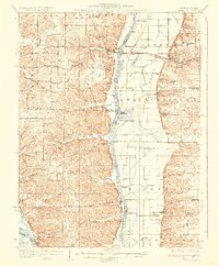
1930 Map of Pearl
USGS Topo · Published 1930About this map
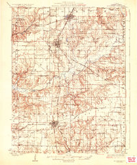
The Illinois River corridor separates the rugged bluffs of Montezuma and Pearl from the wide bottomlands of Walkerville and Fairbanks in this late 1920s survey. The landscape is defined by the Chicago and Alton railroad which services the hillside settlements of Pearl and Hillview. To the west, the deeply dissected terrain is dotted with small country institutions such as Farmers Ridge Ch, Pleasant Dale Ch, and numerous rural schools including Village Green Sch and Summit Grove Sch.
Find a feature on this map
81 named features on this map. Tap any name to fly to it.
Don’t see what you’re looking for? This feature index may not catch every label — zoom into the map to look around manually.
Map Details
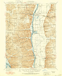
Editions of this 1930 Pearl Map
3 editions found
Other maps of this area

1924 · Winchester
USGS Topo · 1:48,000
1924 · Roodhouse
USGS Topo · 1:62,500

1924 · Griggsville
USGS Topo · 1:62,500

1926 · Griggsville
USGS Topo · 1:62,500
1926 · Pittsfield
USGS Topo · 1:62,500

1926 · Winchester
USGS Topo · 1:62,500
1926 · Roodhouse
USGS Topo · 1:62,500

1930 · Nebo
USGS Topo · 1:62,500

1930 · Hardin
USGS Topo · 1:62,500

1930 · Jerseyville
USGS Topo · 1:62,500