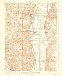
1930 Map of Pearl
USGS Topo · Published 1930About this map
The Illinois River bisects this landscape, separating the intricate bluffs and hollows of Pike Co and Calhoun Co from the agricultural flats of Greene Co. On the western shore, steep-walled valleys like Pleasant Dale Valley and Stearns Hollow reflect the rugged topography of the river breaks, while the eastern side is defined by large-scale land management, including the McClay Orchard and the Chicago and Alton RR corridor connecting Hillview and Eldred.
Find a feature on this map
86 named features on this map. Tap any name to fly to it.
Don’t see what you’re looking for? This feature index may not catch every label — zoom into the map to look around manually.
Map Details
Editions of this 1930 Pearl Map
3 editions found
Other maps of this area

1924 · Winchester
USGS Topo · 1:48,000

1924 · Roodhouse
USGS Topo · 1:62,500

1924 · Griggsville
USGS Topo · 1:62,500

1926 · Griggsville
USGS Topo · 1:62,500

1926 · Pittsfield
USGS Topo · 1:62,500

1926 · Winchester
USGS Topo · 1:62,500

1926 · Roodhouse
USGS Topo · 1:62,500

1930 · Pearl
USGS Topo · 1:62,500

1930 · Nebo
USGS Topo · 1:62,500

1930 · Hardin
USGS Topo · 1:62,500