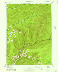
1943 Map of Peekamoose Mountain
USGS Topo · Published 1957About this map
Sundown and Denning serve as the primary human anchors in this mountain-dominated survey of the southern Catskills during the early 1940s. The landscape is defined by the steep drainage basins of the West Branch Neversink Creek and Rondout Creek, which carve deep valleys between high peaks like Slide Mtn and Peekamoose Mt. Small family homesteads and farmsteads are scattered throughout the hollows, including those of H Brooks, W Dubois, and G Singer, providing a detailed record for genealogists researching family landholdings of the era.
Find a feature on this map
65 named features on this map. Tap any name to fly to it.
Don’t see what you’re looking for? This feature index may not catch every label — zoom into the map to look around manually.
Map Details
Editions of this 1943 Peekamoose Mountain Map
3 editions found

Other maps of this area

1900 · Phoenicia
USGS Topo · 1:62,500

1901 · Margaretville
USGS Topo · 1:62,500

1903 · Phoenicia
USGS Topo · 1:62,500

1903 · Slide Mountain
USGS Topo · 1:62,500

1904 · Margaretville
USGS Topo · 1:62,500

1905 · Slide Mountain
USGS Topo · 1:62,500

1910 · Neversink
USGS Topo · 1:62,500

1942 · West Shokan
USGS Topo · 1:24,000

1942 · Neversink
USGS Topo · 1:62,500

1942 · Lackawack
USGS Topo · 1:24,000