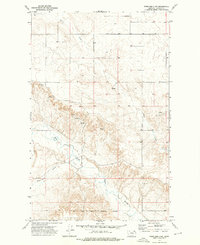
1973 Map of Peerless 4 NW
USGS Topo · Published 1978About this map
The Fort Peck Indian Reservation Boundary marks a significant cultural and political transition across the southern portion of this Daniels County landscape. Surveyed in the early 1970s, the map reveals a rugged terrain defined by the winding course of the West Fork Poplar River and its varied tributaries. The drainage patterns of Police Creek, Hell Creek, and the deep incision of Shipstead Coulee illustrate the complex erosional geography of the northern plains. This area is characterized by isolated agricultural infrastructure, notably the Storage Bins in the western reaches, and numerous Spring points that indicate vital water sources for ranching in an otherwise arid environment. The presence of fine red dashed lines throughout the map highlights the intricate system of selected fence lines, providing a detailed record of land use and property divisions during this era.
Find a feature on this map
8 named features on this map. Tap any name to fly to it.
Don’t see what you’re looking for? This feature index may not catch every label — zoom into the map to look around manually.
Map Details
Editions of this 1973 Peerless 4 NW Map
3 editions found
Other maps of this area

1954 · Wolf Point
USGS Topo · 1:250,000

1958 · Wolf Point
USGS Topo · 1:250,000

1973 · Peerless 4 NE
USGS Topo · 1:24,000

1973 · West Fork NE
USGS Topo · 1:24,000

1973 · Peerless
USGS Topo · 1:24,000

1973 · Killenbeck Reservoir
USGS Topo · 1:24,000

1973 · Peerless 4 SE
USGS Topo · 1:24,000

1973 · Peerless 4 SW
USGS Topo · 1:24,000

1973 · Four Buttes
USGS Topo · 1:24,000

1973 · Poplar Coulee
USGS Topo · 1:24,000