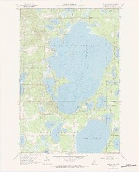
1959 Map of Pelican Lake
USGS Topo · Published 1984About this map
Crow Wing State Forest encompasses much of this 1959 landscape, dominated by the expansive waters of Pelican Lake and Lake Edward. The map documents a transition from lakefront recreation and timber to established community infrastructure, marked by the Pelican Lakes Village Boundary and the presence of the Town Hall and Ossipee Sch. Notable for genealogists and local historians are the numerous smaller water bodies, including Lougee Lake, Markee Lake, and Bonnie Lake, which define the fragmented shoreline and development patterns of the era. The small settlement of Guida sits near the southern edge, while depth curves and soundings provided by the Minnesota Department of Conservation reveal the underwater topography of the major basins. From the Gravel Pit in the northwest to the Pelican Brook outlet, this survey provides a clear view of the mid-century northern woods environment before modern expansion altered the lakefront character.
Find a feature on this map
38 named features on this map. Tap any name to fly to it.
Don’t see what you’re looking for? This feature index may not catch every label — zoom into the map to look around manually.
Map Details
Editions of this 1959 Pelican Lake Map
5 editions found
Other maps of this area

1915 · Brainerd
USGS Topo · 1:62,500

1916 · Pillager
USGS Topo · 1:62,500

1918 · Brainerd
USGS Topo · 1:62,500

1919 · Pillager
USGS Topo · 1:62,500

1953 · Brainerd
USGS Topo · 1:250,000

1957 · Brainerd
USGS Topo · 1:250,000

1958 · Brainerd
USGS Topo · 1:250,000

1959 · Trommald
USGS Topo · 1:24,000

1959 · Pelican Lake
USGS Topo · 1:24,000

1959 · Nisswa
USGS Topo · 1:24,000