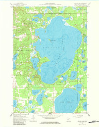
1959 Map of Pelican Lake
USGS Topo · Published 1984About this map
The Breezy Point Corporate Boundary defines the western edge of Pelican Lake, showing a community established around the intricate shorelines of the Pelican Lakes region. This 1959 field-checked survey reveals a landscape where water and woodland dominate, with the Crow Wing State Forest protecting the northeastern quadrant. Local civic and social life is anchored by landmarks such as the Ossipee Sch and the Town Hall, while the presence of a Gravel Pit indicates the small-scale resource extraction typical of the area's development. The map provides depth curves and soundings for the numerous water bodies, including Lake Edward and Ossawinnamakee Lake, detailing a complex aquatic environment before the more intensive lakeside development of later decades. This survey captures the transition from a remote timber and glacial lake district toward an organized municipality at Breezy Point.
Find a feature on this map
35 named features on this map. Tap any name to fly to it.
Don’t see what you’re looking for? This feature index may not catch every label — zoom into the map to look around manually.
Map Details
Editions of this 1959 Pelican Lake Map
5 editions found
Other maps of this area

1915 · Brainerd
USGS Topo · 1:62,500

1916 · Pillager
USGS Topo · 1:62,500

1918 · Brainerd
USGS Topo · 1:62,500

1919 · Pillager
USGS Topo · 1:62,500

1953 · Brainerd
USGS Topo · 1:250,000

1957 · Brainerd
USGS Topo · 1:250,000

1958 · Brainerd
USGS Topo · 1:250,000

1959 · Trommald
USGS Topo · 1:24,000

1959 · Pelican Lake
USGS Topo · 1:24,000

1959 · Nisswa
USGS Topo · 1:24,000