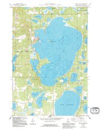
1959 Map of Pelican Lake
USGS Topo · Published 1995About this map
Pelican Lake and Lake Edward dominate this landscape within the Crow Wing State Forest, illustrating the recreational and residential development of central Minnesota in the late 1950s. The village of Breezy Point shows established infrastructure including a Golf Course and a Landing Strip, while the Breezy Point Corporate Bdy delineates the municipal limits during this period of growth.
Find a feature on this map
40 named features on this map. Tap any name to fly to it.
Don’t see what you’re looking for? This feature index may not catch every label — zoom into the map to look around manually.
Map Details
Editions of this 1959 Pelican Lake Map
5 editions found
Other maps of this area

1915 · Brainerd
USGS Topo · 1:62,500

1916 · Pillager
USGS Topo · 1:62,500

1918 · Brainerd
USGS Topo · 1:62,500

1919 · Pillager
USGS Topo · 1:62,500

1953 · Brainerd
USGS Topo · 1:250,000

1957 · Brainerd
USGS Topo · 1:250,000

1958 · Brainerd
USGS Topo · 1:250,000

1959 · Trommald
USGS Topo · 1:24,000

1959 · Pelican Lake
USGS Topo · 1:24,000

1959 · Nisswa
USGS Topo · 1:24,000