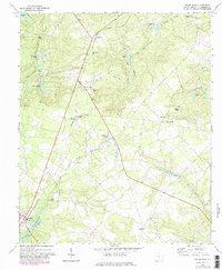
1972 Map of Pelion East
USGS Topo · Published 1982About this map
Southern railroad tracks bisect this Lexington County landscape, connecting the small communities of Edmund, Macedon, and Pelion. The area is characterized by an intricate network of small ponds and creek branches, including Crystal Springs Lake, Spires Pond, and Moragne Pond. These water features feed into larger systems like Bull Swamp and Boggy Creek in the southeast.
Find a feature on this map
43 named features on this map. Tap any name to fly to it.
Don’t see what you’re looking for? This feature index may not catch every label — zoom into the map to look around manually.
Map Details
Editions of this 1972 Pelion East Map
3 editions found
Other maps of this area

1944 · Gilbert
USGS Topo · 1:62,500

1944 · Seivern
USGS Topo · 1:62,500

1944 · Edmund
USGS Topo · 1:62,500

1946 · Woodford
USGS Topo · 1:62,500

1954 · Augusta
USGS Topo · 1:250,000

1957 · Augusta
USGS Topo · 1:250,000

1958 · Augusta
USGS Topo · 1:250,000

1961 · Augusta
USGS Topo · 1:250,000

1962 · Augusta
USGS Topo · 1:250,000
1972 · Lexington
USGS Topo · 1:24,000