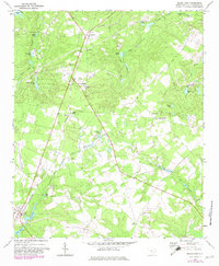
1972 Map of Pelion East
USGS Topo · Published 1982About this map
The Southern railroad line cuts through the heart of Lexington County, connecting the small communities of Edmund, Macedon, and Pelion during the early 1970s. The landscape is a network of small tributaries and numerous named impoundments, such as Crystal Springs Lake, Spires Pond, and Feigles Pond, which likely supported local agriculture or industry. Local social and spiritual life is anchored by numerous rural churches, including Mt Hebron Ch, Bethel Independent Ch, and New Hope Ch, many of which feature adjacent cemeteries that serve as vital records for genealogists. Evidence of specialized land use appears in the form of a Drag Strip and a Landing Strip, while the Hidden Valley Country Club and Sharpes Hill provide distinctive local landmarks. This survey captures a moment of transition for these rural settlements as they began to see more formalized recreation and infrastructure alongside traditional farming and timber interests.
Find a feature on this map
43 named features on this map. Tap any name to fly to it.
Don’t see what you’re looking for? This feature index may not catch every label — zoom into the map to look around manually.
Map Details
Editions of this 1972 Pelion East Map
3 editions found
Other maps of this area

1944 · Gilbert
USGS Topo · 1:62,500

1944 · Seivern
USGS Topo · 1:62,500

1944 · Edmund
USGS Topo · 1:62,500

1946 · Woodford
USGS Topo · 1:62,500

1954 · Augusta
USGS Topo · 1:250,000

1957 · Augusta
USGS Topo · 1:250,000

1958 · Augusta
USGS Topo · 1:250,000

1961 · Augusta
USGS Topo · 1:250,000

1962 · Augusta
USGS Topo · 1:250,000
1972 · Lexington
USGS Topo · 1:24,000