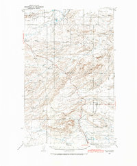
1936 Map of Pendroy
USGS Topo · Published 1986About this map
The Great Northern railway line terminates at Pendroy, a focal point for this Rocky Mountain front landscape surveyed in the mid-1930s. The region is defined by an extensive network of named family ranches and rural schools, including Armstrong Ranch, Sullivan Ranch, and Harmony Sch, reflecting a settled cattle and agricultural economy. Water management is central to life here, evidenced by the Bynum Canal and various irrigation channels drawing from the Marias River and its multiple forks. Along the eastern slopes, several small-scale mining operations like the Hubbard Mine and Kellogg Mine are nestled near Black Buttes. The boundary between Pondera and Teton counties bisects the map, showing how early 20th-century political lines navigated the local coulees and creek beds.
Find a feature on this map
46 named features on this map. Tap any name to fly to it.
Don’t see what you’re looking for? This feature index may not catch every label — zoom into the map to look around manually.
Map Details
Editions of this 1936 Pendroy Map
2 editions found
Other maps of this area

1903 · Saypo
USGS Topo · 1:125,000

1914 · Heart Butte
USGS Topo · 1:125,000

1918 · Heart Butte
USGS Topo · 1:125,000

1920 · Choteau
USGS Topo · 1:125,000

1920 · Dupuyer
USGS Topo · 1:125,000

1934 · Lake Frances
USGS Topo · 1:48,000

1934 · Valier
USGS Topo · 1:62,500

1936 · Pendroy
USGS Topo · 1:48,000

1937 · Valier
USGS Topo · 1:62,500

1937 · Lake Frances
USGS Topo · 1:62,500
Featured Places
- Pendroy, MT
- Rockport Hutterite Colony, MT
- Pondera Hutterite Colony, MT
- Birch Creek Hutterite Colony, MT
- New Miami Hutterite Colony, MT