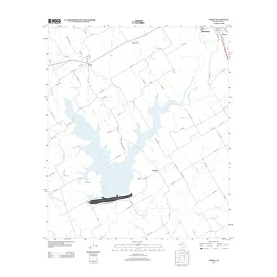
2012 Map of Peoria
USGS Topo · Published 2012About this map
Aquilla Lake dominates this Central Texas landscape, its irregular shoreline reaching north from the dam through the valleys of Aquilla Cr and Hackberry Cr. To the northeast, the outskirts of Hillsboro meet the smaller communities of Winslow and Peoria, reflecting the agricultural and residential patterns of Hill County in the early 21st century. The map provides significant detail for local historians, recording the location of the Culp School and several burial grounds including Vaughan Cem and the Hillcrest Garden of Memory Cem. The terrain is marked by distinct rises such as Union Bluff, while the rural road network, including FM 1947 and FM 1534, connects dispersed farmsteads and small settlements like Vaughan. Tributaries like Rocky Br and Jacks Br feed into the central reservoir, illustrating the local water management and drainage systems.
Find a feature on this map
76 named features on this map. Tap any name to fly to it.
Don’t see what you’re looking for? This feature index may not catch every label — zoom into the map to look around manually.
Map Details
Editions of this 2012 Peoria Map
This is the sole edition of this map. No revisions or reprints were ever made.
Other maps of this area

1891 · Cleburne
USGS Topo · 1:125,000

1892 · Waco
USGS Topo · 1:125,000

1894 · Cleburne
USGS Topo · 1:125,000

1920 · Waco
USGS Topo · 1:125,000

1927 · Blum
USGS Topo · 1:62,500

1931 · Whitney
USGS Topo · 1:62,500

1954 · Dallas
USGS Topo · 1:250,000

1954 · Waco
USGS Topo · 1:250,000

1955 · Waco
USGS Topo · 1:250,000

1956 · Abbott
USGS Topo · 1:24,000