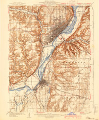
1958 Map of Peoria
USGS Topo · Published 1986About this map
The Illinois River valley serves as the industrial and geographic anchor of this Central Illinois landscape, connecting manufacturing centers like Peoria, Pekin, and East Peoria. The 1958 field data, revised through 1980, captures the region's transition into the interstate era, with Interstate 74 and Interstate 55 bisecting the fertile glacial till plains. Outside the urban hubs of Bloomington and Champaign, the map reveals a dense network of smaller rail-oriented towns such as Chenoa and Gibson City, which flourished as collection points for the surrounding grain belt.
Find a feature on this map
221 named features on this map. Tap any name to fly to it.
Don’t see what you’re looking for? This feature index may not catch every label — zoom into the map to look around manually.
Map Details
Editions of this 1958 Peoria Map
4 editions found

Historical Maps of Peoria Through Time
8 maps found