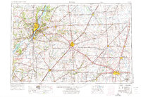
1958 Map of Peoria
USGS Topo · Published 1973About this map
The Illinois River valley serves as the central artery for this 1958 survey, anchoring major industrial and population centers from Peoria to Pekin. The map documents a mature mid-century landscape where heavy rail lines like the Chicago and North Western and Illinois Central Gulf intersect with a burgeoning highway system, connecting agricultural hubs like Bloomington and Champaign. The presence of Chanute AFB near Rantoul highlights the era's military infrastructure, while protected lands like Mason State Forest and Chautauqua NWR along the river bottomlands offer a stark contrast to the surrounding grid of the Illinois prairie. The map captures the intricate drainage network of the Spoon River and Mackinaw River, essential to the region's productive farmland and early settlement patterns.
Find a feature on this map
222 named features on this map. Tap any name to fly to it.
Don’t see what you’re looking for? This feature index may not catch every label — zoom into the map to look around manually.
Map Details
Editions of this 1958 Peoria Map
4 editions found

Other maps of this area

1893 · Lacon
USGS Topo · 1:62,500

1893 · Metamora
USGS Topo · 1:62,500

1893 · Dunlap
USGS Topo · 1:62,500

1898 · Dunlap
USGS Topo · 1:62,500

1905 · Peoria
USGS Topo · 1:62,500

1906 · Urbana
USGS Topo · 1:62,500

1907 · Springfield
USGS Topo · 1:62,500

1907 · Mahomet
USGS Topo · 1:62,500

1909 · Tallula
USGS Topo · 1:62,500

1911 · Lincoln
USGS Topo · 1:62,500