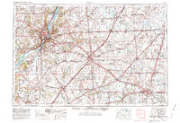
1958 Map of Peoria
USGS Topo · Published 1981About this map
The Illinois River valley serves as the industrial and geographic anchor of this central Illinois region during a period of significant infrastructural expansion. Major urban centers like Peoria, Bloomington, and Champaign are shown connected by an emerging interstate network, including Interstate 74 and Interstate 55, which began to reshape the landscape previously defined by traditional rail corridors. The map details the complex rail environment of the era, featuring lines of the Illinois Central Gulf and the Toledo Peoria and Western.
Find a feature on this map
197 named features on this map. Tap any name to fly to it.
Don’t see what you’re looking for? This feature index may not catch every label — zoom into the map to look around manually.
Map Details
Editions of this 1958 Peoria Map
4 editions found

Other maps of this area

1893 · Lacon
USGS Topo · 1:62,500

1893 · Metamora
USGS Topo · 1:62,500

1893 · Dunlap
USGS Topo · 1:62,500

1898 · Dunlap
USGS Topo · 1:62,500

1905 · Peoria
USGS Topo · 1:62,500

1906 · Urbana
USGS Topo · 1:62,500

1907 · Springfield
USGS Topo · 1:62,500

1907 · Mahomet
USGS Topo · 1:62,500

1909 · Tallula
USGS Topo · 1:62,500

1911 · Lincoln
USGS Topo · 1:62,500