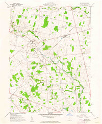
1961 Map of Peoria
USGS Topo · Published 1962About this map
Raymond and Broadway anchor the northern landscape of Union County in the early 1960s, a period defined by small-town agriculture and the enduring infrastructure of regional rail lines. The Erie-Lackawanna and the New York Central rail corridors cut across the terrain, intersecting near Peoria, while the New York Central Railroad Grade marks a path through Liberty. For genealogists, the map is remarkably dense with family-named burial grounds including Raymond Cem, Baughn Cem, and Hamilton Cem, often situated near the meandering banks of Mill Creek or Otter Run. This survey, located within the Virginia Military District, shows the transition of mid-century rural life, where local landmarks like Northwestern High Sch and Calvary Ch served as central community hubs for the surrounding townships of York and Taylor.
Find a feature on this map
26 named features on this map. Tap any name to fly to it.
Don’t see what you’re looking for? This feature index may not catch every label — zoom into the map to look around manually.
Map Details
Editions of this 1961 Peoria Map
4 editions found
Other maps of this area

1913 · East Liberty
USGS Topo · 1:62,500

1913 · Richwood
USGS Topo · 1:62,500

1914 · Mechanicsburg
USGS Topo · 1:62,500

1915 · Richwood
USGS Topo · 1:62,500

1915 · East Liberty
USGS Topo · 1:62,500

1916 · Mechanicsburg
USGS Topo · 1:62,500

1916 · Milford Center
USGS Topo · 1:62,500

1944 · East Liberty
USGS Topo · 1:62,500

1944 · Mechanicsburg
USGS Topo · 1:62,500

1944 · Richwood
USGS Topo · 1:62,500