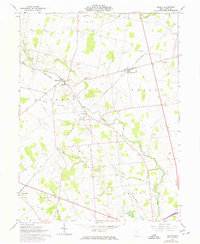
1961 Map of Peoria
USGS Topo · Published 1974About this map
Mill Creek and Otter Run wind through this central Ohio landscape, where the rural character is defined by a dense network of family-named cemeteries and small railway junctions. The intersection of the Penn Central and Erie-Lackawanna railroads at Peoria serves as a focal point for the surrounding farm country. In the northern reaches, the community of Broadway sits along the rail line, while Raymond is home to Northwestern High Sch and several local burial grounds like Raymond Cem and Baughn Cem. The terrain is subtly marked by the industrial footprints of a Substation and a lengthy Pipeline, alongside remnants of earlier transit such as an Old Railroad Grade. Smaller hamlets like Pottersburg and Burns further anchor the local geography in Allen and Liberty townships.
Find a feature on this map
30 named features on this map. Tap any name to fly to it.
Don’t see what you’re looking for? This feature index may not catch every label — zoom into the map to look around manually.
Map Details
Editions of this 1961 Peoria Map
4 editions found
Other maps of this area

1913 · East Liberty
USGS Topo · 1:62,500

1913 · Richwood
USGS Topo · 1:62,500

1914 · Mechanicsburg
USGS Topo · 1:62,500

1915 · Richwood
USGS Topo · 1:62,500

1915 · East Liberty
USGS Topo · 1:62,500

1916 · Mechanicsburg
USGS Topo · 1:62,500

1916 · Milford Center
USGS Topo · 1:62,500

1944 · East Liberty
USGS Topo · 1:62,500

1944 · Mechanicsburg
USGS Topo · 1:62,500

1944 · Richwood
USGS Topo · 1:62,500