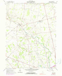
1961 Map of Peoria
USGS Topo · Published 1990About this map
Agricultural life in central Ohio is anchored by the rural villages of Raymond and Peoria during this post-war period. The landscape is defined by the wandering courses of Mill Creek and Otter Run, which cut through a patchwork of family farms and woodlots. Evidence of the region’s older transport networks is visible in the Old Grade Railroad, which runs parallel to the active lines of the Erie-Lackawanna and Penn Central. These rails connect small rail-stop communities like Broadway and Pottersburg to the wider commercial hubs beyond the county line.
Find a feature on this map
29 named features on this map. Tap any name to fly to it.
Don’t see what you’re looking for? This feature index may not catch every label — zoom into the map to look around manually.
Map Details
Editions of this 1961 Peoria Map
4 editions found
Other maps of this area

1913 · East Liberty
USGS Topo · 1:62,500

1913 · Richwood
USGS Topo · 1:62,500

1914 · Mechanicsburg
USGS Topo · 1:62,500

1915 · Richwood
USGS Topo · 1:62,500

1915 · East Liberty
USGS Topo · 1:62,500

1916 · Mechanicsburg
USGS Topo · 1:62,500

1916 · Milford Center
USGS Topo · 1:62,500

1944 · East Liberty
USGS Topo · 1:62,500

1944 · Mechanicsburg
USGS Topo · 1:62,500

1944 · Richwood
USGS Topo · 1:62,500