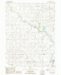
1984 Map of Perdueville
USGS Topo · Published 1985About this map
Perdueville and the surrounding agricultural landscape of Ford and Champaign Counties are defined here by a systematic network of drainage ditches and rail lines. The Norfolk and Western railway cuts east-west across the center of the sheet, while the Illinois Central Gulf runs north-south through the village of Ludlow. The engineering of the land is evident in features like the Big Four Ditch, Town Ditch, and Special Drainage Ditch, which redirect water toward the Upper Salt Fork. Genealogists will find several burial grounds including Meharry Cem and Ten Mile Grove Cem, alongside infrastructure such as the Foster Landing Strip and the Chanute AFB Recreation Area. The map illustrates the specialized utility of the Central Illinois prairie, where aviation, rail transit, and intensive water management converge.
Find a feature on this map
32 named features on this map. Tap any name to fly to it.
Don’t see what you’re looking for? This feature index may not catch every label — zoom into the map to look around manually.
Map Details
Editions of this 1984 Perdueville Map
This is the sole edition of this map. No revisions or reprints were ever made.
Other maps of this area

1924 · Paxton
USGS Topo · 1:62,500

1927 · Paxton
USGS Topo · 1:62,500

1928 · Gibson City
USGS Topo · 1:62,500

1947 · Sibley
USGS Topo · 1:62,500

1948 · Buckley
USGS Topo · 1:62,500

1949 · Buckley
USGS Topo · 1:62,500

1949 · Paxton
USGS Topo · 1:62,500

1949 · Sibley
USGS Topo · 1:62,500

1957 · Paxton
USGS Topo · 1:62,500

1957 · Gibson City
USGS Topo · 1:62,500