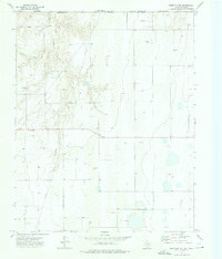
1973 Map of Perryton NW
USGS Topo · Published 1976About this map
Chiquita Creek meanders through the northwest corner of Ochiltree County in this early 1970s survey, marking a distinct break in the High Plains terrain. The landscape is defined by the heavy infrastructure of the energy industry, dominated by a sprawling Oil and Gas Field that stretches across the central and eastern portions of the quadrangle. A network of pipelines and numerous scattered oil wells and gas wells illustrate the intensive resource extraction of the era. Located along the border with Oklahoma, the map shows the transition from the breaks of Hackberry in the north to the more level agricultural or grazing land to the south. Small-scale industrial activity is also evident through several Gravel Pits located near the creek banks, providing material for the local road network that sections the plains into a regular grid.
Find a feature on this map
14 named features on this map. Tap any name to fly to it.
Don’t see what you’re looking for? This feature index may not catch every label — zoom into the map to look around manually.
Map Details
Editions of this 1973 Perryton NW Map
This is the sole edition of this map. No revisions or reprints were ever made.
Other maps of this area

1954 · Perryton
USGS Topo · 1:250,000

1958 · Perryton
USGS Topo · 1:250,000

1968 · Hardesty SE
USGS Topo · 1:24,000

1973 · Farnsworth
USGS Topo · 1:24,000

1973 · Horseshoe Hill
USGS Topo · 1:24,000

1973 · Perryton SE
USGS Topo · 1:24,000

1973 · Perryton
USGS Topo · 1:24,000

1973 · Waka
USGS Topo · 1:24,000

1973 · Bryans Corner SW
USGS Topo · 1:24,000

1973 · Bryans Corner
USGS Topo · 1:24,000