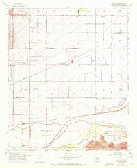
1957 Map of Perryville
USGS Topo · Published 1972About this map
Agricultural development and early cold-war aviation infrastructure define this portion of the Gila River Valley west of Phoenix. The landscape is structured by a grid of named rural roads, including Indian School Road and Jackrabbit Trail, which service a network of vital irrigation systems like the Beardsley Canal and Roosevelt Canal. Small settlements such as Perryville and McMicken are centers for local activity, while the presence of a Labor Camp and a Trailer Park reflects the era's labor and housing patterns.
Find a feature on this map
47 named features on this map. Tap any name to fly to it.
Don’t see what you’re looking for? This feature index may not catch every label — zoom into the map to look around manually.
Map Details
Editions of this 1957 Perryville Map
5 editions found
Other maps of this area

1946 · Avondale
USGS Topo · 1:62,500

1948 · Cashion
USGS Topo · 1:62,500

1954 · Phoenix
USGS Topo · 1:250,000

1957 · Phoenix
USGS Topo · 1:250,000

1957 · White Tank Mts. SE
USGS Topo · 1:24,000

1957 · Valencia
USGS Topo · 1:24,000

1957 · Perryville
USGS Topo · 1:24,000

1957 · El Mirage
USGS Topo · 1:24,000

1957 · Waddell
USGS Topo · 1:24,000

1957 · Tolleson
USGS Topo · 1:24,000