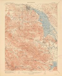
1914 Map of Petaluma
USGS Topo · Published 1914About this map
Petaluma serves as the bustling hub of this northern California landscape, where the Northwestern Pacific railroad corridor meets the winding tidal reaches of Petaluma Creek. The map illustrates a transition from the structured grid of the city to the expansive ranchlands and valleys defined by old Mexican land grants like Roblar de la Miseria and Olompali. This era is marked by a high density of rural schoolhouses, such as the Eureka School and San Antonio School, which anchored the diverse agricultural communities before the mid-century suburban shift.
Find a feature on this map
104 named features on this map. Tap any name to fly to it.
Don’t see what you’re looking for? This feature index may not catch every label — zoom into the map to look around manually.
Map Details
Editions of this 1914 Petaluma Map
5 editions found
Other maps of this area

1895 · San Francisco
USGS Topo · 1:62,500

1897 · Tamalpais
USGS Topo · 1:62,500

1899 · San Francisco
USGS Topo · 1:62,500

1902 · Napa
USGS Topo · 1:125,000

1914 · Petaluma
USGS Topo · 1:62,500

1915 · San Francisco
USGS Topo · 1:62,500

1916 · Mare Island
USGS Topo · 1:62,500

1916 · Santa Rosa
USGS Topo · 1:62,500

1916 · Point Reyes
USGS Topo · 1:48,000

1918 · Point Reyes
USGS Topo · 1:62,500