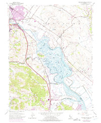
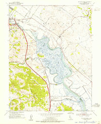
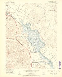
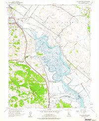
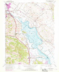
1954 Map of Petaluma River
USGS Topo · Published 1975About this map
The Petaluma River serves as the central artery for this mid-century landscape, where the tidal marshes and winding sloughs of the northern San Pablo Bay interface with the rising slopes of Burdell Mtn. The transport network is particularly well-defined, showing the Northwestern Pacific railroad corridor and the Pacific Highway skirting the wetlands. These routes connect established points like Petaluma and Lakeville with smaller landings and stops such as McNear and Haystack.
Find a feature on this map
43 named features on this map. Tap any name to fly to it.
Don’t see what you’re looking for? This feature index may not catch every label — zoom into the map to look around manually.
Map Details
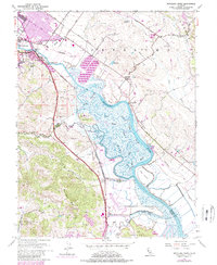
Editions of this 1954 Petaluma River Map
7 editions found
Historical Maps of Petaluma Through Time
133 maps found

1916 Mare Island
Sonoma County, CA

1921 Plantation
Sonoma County, CA

1921 Skaggs
Sonoma County, CA

1942 Arched Rock
Sonoma County, CA

1942 Bodega Head
Sonoma County, CA

1942 Mare Island
Sonoma County, CA

1943 Annapolis
Sonoma County, CA

1943 Duncans Mills
Sonoma County, CA

1943 Fort Ross
Sonoma County, CA

1943 Plantation
Sonoma County, CA

1943 Skaggs Springs
Sonoma County, CA

1943 Stewarts Point
Sonoma County, CA

1943 Tombs Creek
Sonoma County, CA

1944 Annapolis
Sonoma County, CA

1944 Arched Rock
Sonoma County, CA

1944 Bodega Head
Sonoma County, CA

1944 Fort Ross
Sonoma County, CA

1944 Plantation
Sonoma County, CA

1944 Skaggs Springs
Sonoma County, CA

1944 Stewarts Point
Sonoma County, CA

1945 Duncans Mills
Sonoma County, CA

1945 Tombs Creek
Sonoma County, CA

1951 Sears Point
Sonoma County, CA

1952 Duncans Mills
Sonoma County, CA

1954 Camp Meeker
Sonoma County, CA

1954 Petaluma River
Sonoma County, CA

1954 Two Rock
Sonoma County, CA

1955 Jimtown
Sonoma County, CA

1958 Mark West Springs
Sonoma County, CA

1959 Asti
Sonoma County, CA

1959 Mount St. Helena
Sonoma County, CA

1959 The Geysers
Sonoma County, CA

1972 Bodega Head
Sonoma County, CA

1977 Annapolis
Sonoma County, CA

1977 Arched Rock
Sonoma County, CA

1977 Plantation
Sonoma County, CA

1978 Fort Ross
Sonoma County, CA

1978 Stewarts Point
Sonoma County, CA

1978 Tombs Creek
Sonoma County, CA

1978 Warm Springs Dam
Sonoma County, CA

1979 Duncans Mills
Sonoma County, CA

1993 Asti
Sonoma County, CA

1993 Jimtown
Sonoma County, CA

1993 Mark West Springs
Sonoma County, CA

1993 Mount St. Helena
Sonoma County, CA

1993 The Geysers
Sonoma County, CA

1995 Camp Meeker
Sonoma County, CA

1997 Mount Saint Helena
Sonoma County, CA

1998 Asti
Sonoma County, CA

1998 Fort Ross
Sonoma County, CA

1998 Mark West Springs
Sonoma County, CA

2012 Annapolis
Sonoma County, CA

2012 Arched Rock
Sonoma County, CA

2012 Asti
Sonoma County, CA

2012 Bodega Head
Sonoma County, CA

2012 Camp Meeker
Sonoma County, CA

2012 Duncans Mills
Sonoma County, CA

2012 Fort Ross
Sonoma County, CA

2012 Jimtown
Sonoma County, CA

2012 Mark West Springs
Sonoma County, CA

2012 Mount Saint Helena
Sonoma County, CA

2012 Petaluma River
Sonoma County, CA

2012 Plantation OE W
Sonoma County, CA

2012 Plantation
Sonoma County, CA

2012 Sears Point
Sonoma County, CA

2012 Stewarts Point OE W
Sonoma County, CA

2012 Stewarts Point
Sonoma County, CA

2012 The Geysers
Sonoma County, CA

2012 Tombs Creek
Sonoma County, CA

2012 Two Rock
Sonoma County, CA

2012 Warm Springs Dam
Sonoma County, CA

2015 Annapolis
Sonoma County, CA

2015 Arched Rock
Sonoma County, CA

2015 Asti
Sonoma County, CA

2015 Bodega Head
Sonoma County, CA

2015 Camp Meeker
Sonoma County, CA

2015 Duncans Mills
Sonoma County, CA

2015 Fort Ross
Sonoma County, CA

2015 Jimtown
Sonoma County, CA

2015 Mark West Springs
Sonoma County, CA

2015 Mount Saint Helena
Sonoma County, CA

2015 Petaluma River
Sonoma County, CA

2015 Plantation OE W
Sonoma County, CA

2015 Plantation
Sonoma County, CA

2015 Sears Point
Sonoma County, CA

2015 Stewarts Point OE W
Sonoma County, CA

2015 Stewarts Point
Sonoma County, CA

2015 The Geysers
Sonoma County, CA

2015 Tombs Creek
Sonoma County, CA

2015 Two Rock
Sonoma County, CA

2015 Warm Springs Dam
Sonoma County, CA

2018 Annapolis
Sonoma County, CA

2018 Arched Rock
Sonoma County, CA

2018 Asti
Sonoma County, CA

2018 Bodega Head
Sonoma County, CA

2018 Camp Meeker
Sonoma County, CA

2018 Duncans Mills
Sonoma County, CA

2018 Fort Ross
Sonoma County, CA

2018 Jimtown
Sonoma County, CA

2018 Mark West Springs
Sonoma County, CA

2018 Mount Saint Helena
Sonoma County, CA

2018 Petaluma River
Sonoma County, CA

2018 Plantation OE W
Sonoma County, CA

2018 Plantation
Sonoma County, CA

2018 Sears Point
Sonoma County, CA

2018 Stewarts Point OE W
Sonoma County, CA

2018 Stewarts Point
Sonoma County, CA

2018 The Geysers
Sonoma County, CA

2018 Tombs Creek
Sonoma County, CA

2018 Two Rock
Sonoma County, CA

2018 Warm Springs Dam
Sonoma County, CA

2021 Annapolis
Sonoma County, CA

2021 Arched Rock
Sonoma County, CA

2021 Asti
Sonoma County, CA

2021 Bodega Head
Sonoma County, CA

2021 Camp Meeker
Sonoma County, CA

2021 Duncans Mills
Sonoma County, CA

2021 Fort Ross
Sonoma County, CA

2021 Jimtown
Sonoma County, CA

2021 Mark West Springs
Sonoma County, CA

2021 Mount Saint Helena
Sonoma County, CA

2021 Petaluma River
Sonoma County, CA

2021 Plantation OE W
Sonoma County, CA

2021 Plantation
Sonoma County, CA

2021 Sears Point
Sonoma County, CA

2021 Stewarts Point OE W
Sonoma County, CA

2021 Stewarts Point
Sonoma County, CA

2021 The Geysers
Sonoma County, CA

2021 Tombs Creek
Sonoma County, CA

2021 Two Rock
Sonoma County, CA

2021 Warm Springs Dam
Sonoma County, CA

2023 Asti
Sonoma County, CA

2023 The Geysers
Sonoma County, CA