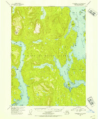
1953 Map of Petersburg A-4
USGS Topo · Published 1954About this map
Prince of Wales Island dominates this mid-century survey of the Alexander Archipelago, showing the intricate coastline before modern development. The landscape is defined by its complex waterways, including the broad Whale Passage and Kashevarof Passage, which separate numerous smaller landmasses like Thorne Island and Kosciusko Island. A notable human imprint is found at Camp Taylor (Aban'd) near Sarkeen Cove, indicating the shifting nature of early 20th-century outposts in the Tongass National Forest. Inland, the terrain rises sharply toward El Capitan Peak, with freshwater features like Neck Lake and Salmon Bay Lake connected by small drainages such as Squaw Creek. The map reflects a maritime-dependent geography where every point, including Aneskett Pt, and cove served as vital landmarks for navigation through the island's many passages.
Find a feature on this map
26 named features on this map. Tap any name to fly to it.
Don’t see what you’re looking for? This feature index may not catch every label — zoom into the map to look around manually.
Map Details
Editions of this 1953 Petersburg A-4 Map
2 editions found

Other maps of this area

1948 · Petersburg B-3
USGS Topo · 1:63,360

1949 · Craig D-3
USGS Topo · 1:63,360

1949 · Petersburg B-5
USGS Topo · 1:63,360

1949 · Petersburg A-3
USGS Topo · 1:63,360

1949 · Craig D-4
USGS Topo · 1:63,360

1949 · Petersburg A-5
USGS Topo · 1:63,360

1949 · Petersburg A-4
USGS Topo · 1:63,360

1949 · Petersburg B-4
USGS Topo · 1:63,360

1950 · Craig D-3
USGS Topo · 1:63,360

1951 · Craig D-5
USGS Topo · 1:63,360