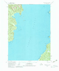
1951 Map of Petersburg A-6
USGS Topo · Published 1983About this map
Sumner Strait dominates this mid-century maritime chart, separating the shorelines of Kuiu Island to the west and Kosciusko Island to the southeast. The survey area, situated within the Tongass National Forest, captures the intricate coastline of the Alexander Archipelago before modern development. Notable coastal landmarks include the sharp profile of Pt Amelius and the sheltered waters of Louise Cove. To the south, Pt St Albans anchors a rugged peninsula, while the eastern side of the strait is dotted with features like Ruins Pt and Finger Is. The map provides a detailed view of the natural topography of this timber-rich region, documenting the positions of small islands like Amelius I and Bluff I alongside drainage systems such as Trout Creek and Charles Creek.
Find a feature on this map
19 named features on this map. Tap any name to fly to it.
Don’t see what you’re looking for? This feature index may not catch every label — zoom into the map to look around manually.
Map Details
Editions of this 1951 Petersburg A-6 Map
4 editions found

Other maps of this area

1948 · Petersburg A-6
USGS Topo · 1:63,360

1948 · Port Alexander A-1
USGS Topo · 1:63,360

1948 · Petersburg B-6
USGS Topo · 1:63,360

1948 · Port Alexander B-1
USGS Topo · 1:63,360

1949 · Petersburg B-5
USGS Topo · 1:63,360

1949 · Petersburg A-5
USGS Topo · 1:63,360

1951 · Craig D-6
USGS Topo · 1:63,360

1951 · Craig D-5
USGS Topo · 1:63,360

1951 · Port Alexander
USGS Topo · 1:250,000

1951 · Petersburg B-6
USGS Topo · 1:63,360