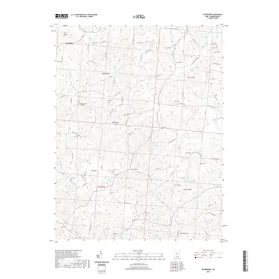
2019 Map of Petersburg
USGS Topo · Published 2019About this map
Petersburg sits in the northwestern corner of this Jackson County landscape, where the terrain is defined by a dense network of hollows and ridges. For genealogists, the map is particularly rich with family-named burial sites, including the Crabtree Cem Number 1, Masters Cem, and Jacobs Cem. The local transport network relies on a web of township and county roads that navigate the complex drainage patterns of Holland Fork and Sugar Camp Cr. Central to the area is Riegel Ridge, which forms a prominent divide between the various creek beds. The southern portion of the quadrangle is marked by Dever Valley, while the small-scale aviation history of the region is represented by Russ Airport. These features collectively reveal a rural Ohio community where the historical footprint of early settlers remains visible through numerous small cemeteries and family landmarks like Pigeonroost Hollow.
Find a feature on this map
100 named features on this map. Tap any name to fly to it.
Don’t see what you’re looking for? This feature index may not catch every label — zoom into the map to look around manually.
Map Details
Editions of this 2019 Petersburg Map
This is the sole edition of this map. No revisions or reprints were ever made.
Other maps of this area

1906 · Waverly
USGS Topo · 1:62,500

1908 · Waverly
USGS Topo · 1:62,500

1911 · Sciotoville
USGS Topo · 1:62,500

1912 · Oak Hill
USGS Topo · 1:62,500

1913 · Sciotoville
USGS Topo · 1:62,500

1913 · Jackson
USGS Topo · 1:62,500

1944 · Jackson
USGS Topo · 1:62,500

1947 · Columbus
USGS Topo · 1:250,000

1957 · Huntington
USGS Topo · 1:250,000

1960 · Huntington
USGS Topo · 1:250,000