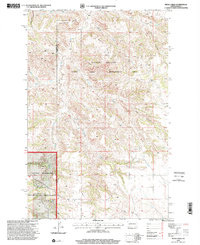
1997 Map of Petes Creek
USGS Topo · Published 2001About this map
Killdeer Mountain dominates the center of this landscape, a high plateau rising above a complex network of drainage divides. The map captures the western North Dakota badlands and prairie as it appeared in the late 1990s, characterized by a mix of wildlife conservation and energy extraction. Much of the northern terrain is dedicated to the State Game Management Area, while the southwestern corner transitions into the Little Missouri National Grassland.
Find a feature on this map
22 named features on this map. Tap any name to fly to it.
Don’t see what you’re looking for? This feature index may not catch every label — zoom into the map to look around manually.
Map Details
Editions of this 1997 Petes Creek Map
This is the sole edition of this map. No revisions or reprints were ever made.
Other maps of this area

1953 · Watford City
USGS Topo · 1:250,000

1957 · Watford City
USGS Topo · 1:250,000

1958 · Lone Butte SE
USGS Topo · 1:24,000

1958 · Lone Butte
USGS Topo · 1:24,000

1958 · North Killdeer Mountain
USGS Topo · 1:24,000

1967 · Watford City
USGS Topo · 1:250,000

1974 · Killdeer
USGS Topo · 1:100,000

1974 · Grassy Butte SW
USGS Topo · 1:24,000

1974 · Petes Creek
USGS Topo · 1:24,000

1974 · Fayette
USGS Topo · 1:24,000