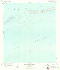
1958 Map of Petit Bois Pass
USGS Topo · Published 1959About this map
Dauphin Island tapers into the Gulf of Mexico waters in this late-1950s survey, documenting the maritime environment of the Alabama coast. The map focuses on the dynamic seafloor and shifting sands where the Mississippi Sound meets the open sea. Of particular interest to maritime historians and divers is the specific notation of Wreckage located just west of the primary channel, a detail likely sourced from the Usc&GS hydrographic charts of the era. The sounding data reveals the navigable depth of Petit Bois Pass, illustrating the coastal geography before modern storm cycles further reshaped these barrier islands. This document serves as a precise record of the shoreline and shoals at a time when the region was primarily defined by its natural topography and fishing waters.
Find a feature on this map
5 named features on this map. Tap any name to fly to it.
Don’t see what you’re looking for? This feature index may not catch every label — zoom into the map to look around manually.
Map Details
Editions of this 1958 Petit Bois Pass Map
2 editions found
Other maps of this area

1921 · Grand Bay
USGS Topo · 1:62,500

1921 · Petit Bois Island
USGS Topo · 1:62,500

1921 · Dauphin Island
USGS Topo · 1:62,500

1921 · Delchamps
USGS Topo · 1:62,500

1941 · Cedar Point
USGS Topo · 1:62,500

1942 · Petit Bois Island
USGS Topo · 1:62,500

1942 · Fort Morgan
USGS Topo · 1:62,500

1943 · Cedar Point
USGS Topo · 1:62,500

1943 · Grand Bay
USGS Topo · 1:62,500

1953 · Mobile
USGS Topo · 1:250,000