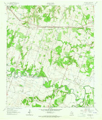
1962 Map of Pettibone
USGS Topo · Published 1964About this map
The Gulf Colorado And Santa Fe railroad cuts a straight path through the northern half of this Milam County landscape, serving the small community of Pettibone and the larger town of Buckholts. To the south, the meandering Little River creates a starkly different topography, characterized by intricate oxbows and marshy lowlands like Ackerman Slough and Spring Slough.
Find a feature on this map
30 named features on this map. Tap any name to fly to it.
Don’t see what you’re looking for? This feature index may not catch every label — zoom into the map to look around manually.
Map Details
Editions of this 1962 Pettibone Map
2 editions found
Other maps of this area

1885 · Taylor
USGS Topo · 1:125,000

1887 · Taylor
USGS Topo · 1:125,000

1894 · Taylor
USGS Topo · 1:125,000

1910 · Buckholts
USGS Topo · 1:24,000

1912 · Buckholts
USGS Topo · 1:31,680

1954 · Austin
USGS Topo · 1:250,000

1956 · Milano
USGS Topo · 1:62,500

1961 · Cameron
USGS Topo · 1:24,000

1961 · Rockdale East
USGS Topo · 1:24,000

1962 · Rockdale West
USGS Topo · 1:24,000