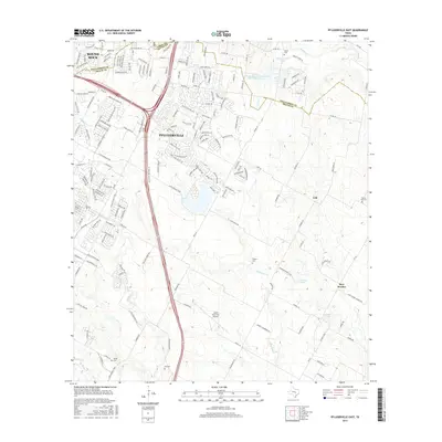
2016 Map of Pflugerville East
USGS Topo · Published 2016About this map
Pflugerville and the neighboring rural communities of Cele and New Sweden occupy this portion of the Texas Blackland Prairies where the Williamson and Travis county line divides the landscape. The suburban expansion of the 2010s is evident in the dense street networks of north Round Rock and western Pflugerville, which contrast sharply with the agricultural heritage preserved in the east. Numerous family and community burial grounds, such as Pfluger Cem, Shiloh Cem, and Gregg Cem, are scattered across the terrain, serving as vital landmarks for genealogists. The modern transportation infrastructure is anchored by the Austin Executive Airport and the Missouri Pacific railroad, while the drainage of the region is defined by the winding paths of Wilbarger Cr, Gilleland Cr, and Brushy Cr. Smaller reservoirs like Zimmerhanzel Lake and Raesz Lake dot the rural sectors, reflecting the water management essential to this prairie environment.
Find a feature on this map
181 named features on this map. Tap any name to fly to it.
Don’t see what you’re looking for? This feature index may not catch every label — zoom into the map to look around manually.
Map Details
Editions of this 2016 Pflugerville East Map
This is the sole edition of this map. No revisions or reprints were ever made.
Other maps of this area

1885 · Taylor
USGS Topo · 1:125,000

1885 · Bastrop
USGS Topo · 1:125,000

1887 · Taylor
USGS Topo · 1:125,000

1893 · Georgetown
USGS Topo · 1:125,000

1893 · Bastrop
USGS Topo · 1:125,000

1894 · Taylor
USGS Topo · 1:125,000

1896 · Austin
USGS Topo · 1:125,000

1897 · Austin
USGS Topo · 1:125,000

1904 · Bastrop
USGS Topo · 1:125,000

1910 · Austin
USGS Topo · 1:125,000