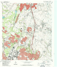
1987 Map of Pflugerville West
USGS Topo · Published 1987About this map
The northern reaches of Austin and the growing community of Pflugerville meet at the Williamson Co and Travis Co line during this 1987 update. The map documents an era of suburban expansion and institutional development, dominated by the sprawling University of Texas Balcones Research Center in the southwest and the Austin Executive Airpark further east. Transportation corridors like the Missouri Pacific and Southern Pacific railroads cut through the landscape, alongside a maturing road network featuring Howard Lane and Palmer Lane. Smaller, established locales such as Merrelltown, McNeil, and Coxville are still visible amidst new subdivisions and industrial sites like the Filtration Plant. Significant local landmarks include Capitol Memorial Park and several education centers, including Pflugerville High School, illustrating the shift from rural holdings to a structured metropolitan fringe.
Find a feature on this map
59 named features on this map. Tap any name to fly to it.
Don’t see what you’re looking for? This feature index may not catch every label — zoom into the map to look around manually.
Map Details
Editions of this 1987 Pflugerville West Map
2 editions found
Other maps of this area

1893 · Georgetown
USGS Topo · 1:125,000

1896 · Austin
USGS Topo · 1:125,000

1897 · Austin
USGS Topo · 1:125,000

1910 · Austin
USGS Topo · 1:125,000

1925 · Georgetown 4-d
USGS Topo · 1:48,000

1928 · Round Rock
USGS Topo · 1:62,500

1932 · Mt. Bonnell
USGS Topo · 1:62,500

1949 · Round Rock
USGS Topo · 1:62,500

1951 · Round Rock
USGS Topo · 1:62,500

1954 · Austin East
USGS Topo · 1:24,000