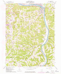
1961 Map of Philo
USGS Topo · Published 1977About this map
The Muskingum River dominates this landscape, serving as a historic corridor for the Baltimore and Ohio railroad and the neighboring settlements of Philo and Duncan Falls. In the early 1960s, this region of Muskingum County was defined by a mix of intensive land use and rugged natural terrain, where extensive strip mines carved into ridges near Cannelville and Stovertown contrasted with the deep woodlands of the Blue Rock State Forest.
Find a feature on this map
58 named features on this map. Tap any name to fly to it.
Don’t see what you’re looking for? This feature index may not catch every label — zoom into the map to look around manually.
Map Details
Editions of this 1961 Philo Map
4 editions found
Other maps of this area

1910 · Philo
USGS Topo · 1:62,500

1910 · Zanesville
USGS Topo · 1:62,500

1910 · Mc Connelsville
USGS Topo · 1:62,500

1911 · New Lexington
USGS Topo · 1:62,500

1947 · Columbus
USGS Topo · 1:250,000

1949 · Clarksburg
USGS Topo · 1:250,000

1956 · Clarksburg
USGS Topo · 1:250,000

1961 · Columbus
USGS Topo · 1:250,000

1961 · Clarksburg
USGS Topo · 1:250,000

1961 · Mc Connelsville
USGS Topo · 1:24,000